Block faulting in the eastern Sierra Nevada Mountains created a basin that filled with water. This created beautiful Lake Tahoe, which straddles the California-Nevada border. The lake has been exceedingly clear though its history, although now development around the lake has resulted in some loss of clarity.
Ponds
Ponds are small bodies of fresh water that usually have no outlet; ponds are often are fed by underground springs. Like lakes, ponds are bordered by hills or low rises so the water is blocked from flowing directly downhill.
Lakes
Lakes are larger bodies of water. Lakes are usually fresh water, although the Great Salt Lake in Utah is just one exception. Water usually drains out of a lake through a river or a stream and all lakes lose water to evaporation.
Lakes form in a variety of different ways: in depressions carved by glaciers, in calderas (Figurebelow), and along tectonic faults, to name a few. Subglacial lakes are even found below a frozen ice cap.
(a) Crater Lake in Oregon is in a volcanic caldera. Lakes can also form in volcanic craters and impact craters. (b) The Great Lakes fill depressions eroded as glaciers scraped rock out from the landscape. (c) Lake Baikal, ice coated in winter in this image, formed as water filled up a tectonic faults.
As a result of geologic history and the arrangement of land masses, most lakes are in the Northern Hemisphere. In fact, more than 60% of all the world’s lakes are in Canada — most of these lakes were formed by the glaciers that covered most of Canada in the last Ice Age (Figurebelow).
Lakes near Yellowknife were carved by glaciers during the last Ice Age.
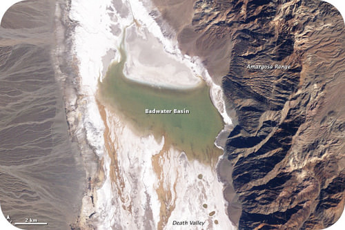
Lakes are not permanent features of a landscape. Some come and go with the seasons, as water levels rise and fall. Over a longer time, lakes disappear when they fill with sediments, if the springs or streams that fill them diminish, or if their outlets grow because of erosion. When the climate of an area changes, lakes can either expand or shrink (Figurebelow). Lakes may disappear if precipitation significantly diminishes.
The Badwater Basin in Death Valley contains water in wet years. The lake basin is a remnant from when the region was much wetter just after the Ice Ages.
Large lakes have tidal systems and currents, and can even affect weather patterns. The Great Lakes in the United States contain 22% of the world’s fresh surface water (Figureabove). The largest them, Lake Superior, has a tide that rises and falls several centimeters each day. The Great Lakes are large enough to alter the weather system in Northeastern United States by the “lake effect,” which is an increase in snow downwind of the relatively warm lakes. The Great Lakes are home to countless species of fish and wildlife.
Many lakes are not natural, but are human-made. People dam a stream in a suitable spot and then let the water back up behind it, creating a lake. These lakes are called "reservoirs."
Summary
Ponds are small water bodies often fed by springs.
A lake may form in many locations, including a volcanic crater, where a glacier has carved out a depression, or a fault zone.
Lakes have surface, open-water, and deep-water zones.
Review
What is the reason that Earth has many more lakes than is normal during Earth's history? What will happen as climate warms?
What are some of the ways lakes can form?
What is the difference between ponds and lakes? How are they similar?
Explore More
Use this resource to answer the questions that follow.
What are the names for the zones: nearshore; open water; deep water; bottom surface
Why does a large lake harbor a lot of life?
What is a typical temperate zone lake like in the summer? What is the temperature structure?
What is a typical temperate zone lake like in the autumn? What is the temperature structure?
What is a typical temperate zone lake like in the winter? What is the temperature structure?
What is different about a lake in a tropical region?
Why doesn't a lake live forever?
Vocabulary
termdefinition
lakea large body of freshwater drained by a stream; naturally occurring or human-made.
ponda small body of freshwater, with no stream draining it; it can be fed by an underground spring.
Notes/Highlights
Color
Highlighted Text
Notes
Please Sign In to create your own Highlights / Notes


 FlexiA FREE Digital Tutor for Every Student
 FlexBooks 2.0Customizable, digital textbooks in a new, interactive platform
 FlexBooksCustomizable, digital textbooks
 SchoolsFlexBooks from schools and districts near you
 Study GuidesQuick review with key information for each concept
 Adaptive PracticeBuilding knowledge at each student’s skill level
 SimulationsInteractive Physics & Chemistry Simulations
 PLIXPlay. Learn. Interact. eXplore.
 CCSS MathConcepts and FlexBooks aligned to Common Core
 NGSSConcepts aligned to Next Generation Science Standards
 Certified EducatorStand out as an educator. Become CK-12 Certified.
 WebinarsLive and archived sessions to learn about CK-12