What a confusing map! It shows the locations of a few important features in Yellowstone, including Old Faithful, trails, development, trees, streams, and hillsides. But it has all those squiggly lines! Look carefully and try to notice some features about the lines. For example, they don't cross. In some locations they are so close together they nearly form a solid and in other locations they are much farther apart. What is this map trying to tell you?
Topographic Maps
Topographic maps represent the locations of geographical features, such as hills and valleys. Topographic maps use contour lines to show different elevations. A contour line is a line of equal elevation. If you walk along a contour line you will not go uphill or downhill. Topographic maps are also called contour maps. The rules of topographic maps are:
Each line connects all points of a specific elevation.
Contour lines never cross since a single point can only have one elevation.
Every fifth contour line is bolded and labeled.
Adjacent contour lines are separated by a constant difference in elevation (such as 20 ft or 100 ft). The difference in elevation is the contour interval, which is indicated in the map legend.
Scales indicate horizontal distance and are also found on the map legend.
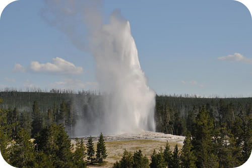
Old Faithful erupting, Yellowstone National Park.
While the Figureabove isn’t exactly the same view as the map at the top of this concept, it is easy to see the main features. Hills, forests, development, and trees are all seen around Old Faithful.
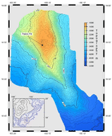
Bathymetric Maps
A bathymetric map is like a topographic map with the contour lines representing depth below sea level, rather than height above. Numbers are low near sea level and become higher with depth.
Kilauea is the youngest volcano found above sea level in Hawaii. On the flank of Kilauea is an even younger volcano called Loihi. The bathymetric map pictured in the Figurebelow shows the form of Loihi.
Loihi volcano growing on the flank of Kilauea volcano in Hawaii. Black lines in the inset show the land surface above sea level and blue lines show the topography below sea level.
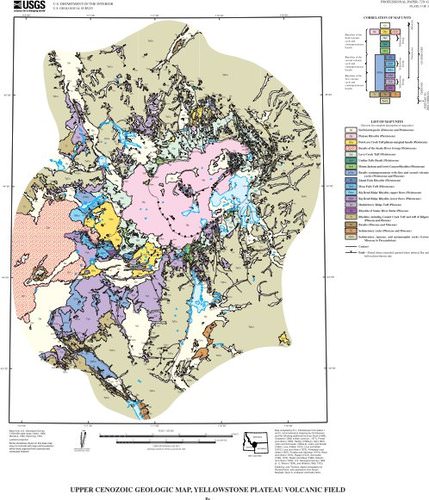
Geologic Maps
A geologic map of the region around Old Faithful, Yellowstone National Park.
A geologic map shows the geological features of a region (see Figureabove for an example). Rock units are color-coded and identified in a key. Faults and folds are also shown on geologic maps. The geology is superimposed on a topographic map to give a more complete view of the geology of the region.
Summary
Earth scientists regularly use topographic, bathymetric, and geologic maps.
Topographic maps reveal the shape of a landscape. Elevations indicate height above sea level.
Bathymetric maps are like topographic maps of features found below the water. Elevations indicate depth below sea level.
Geologic maps show rock units and geologic features like faults and folds.
Review
What will a hill look like on a topographic map? How will a basin look different from a hill?
How will a steep slope look different from a shallow slope?
What would a geologic map of the Grand Canyon look like? Remember that the Grand Canyon has many layers of rocks exposed like a layer cake.
Explore More
Use this resource to answer the questions that follow. You may stop watching at the 4:04 mark.
What do topographic maps do and how do they do it?
What are the meanings of the terms topographic map, contour line, contour interval and index contour?
If you were to walk along a contour line, what would happen to your elevation?
If you walk perpendicular to contour lines what are you doing?
What do close contour lines indicate?
Vocabulary
termdefinition
bathymetric mapa topographic map that shows depth below sea level to indicate geographic features; these maps are created from the measurement of ocean depths using echo sounders.
contour intervalthe constant difference in elevation between two contour lines on a topographic map.
contour linea line on a topographic map to show elevation; one line connects all the places that are the same elevation.
geologic mapa map showing the geologic features, such as rock units and structures, of a region.
topographic mapa map that shows elevations above sea level to indicate geographic feature; also called contour map.
Notes/Highlights
Color
Highlighted Text
Notes
Please Sign In to create your own Highlights / Notes


 FlexiA FREE Digital Tutor for Every Student
 FlexBooks 2.0Customizable, digital textbooks in a new, interactive platform
 FlexBooksCustomizable, digital textbooks
 SchoolsFlexBooks from schools and districts near you
 Study GuidesQuick review with key information for each concept
 Adaptive PracticeBuilding knowledge at each student’s skill level
 SimulationsInteractive Physics & Chemistry Simulations
 PLIXPlay. Learn. Interact. eXplore.
 CCSS MathConcepts and FlexBooks aligned to Common Core
 NGSSConcepts aligned to Next Generation Science Standards
 Certified EducatorStand out as an educator. Become CK-12 Certified.
 WebinarsLive and archived sessions to learn about CK-12