Why is the Republic of Indonesia made of 17,508 islands?
Around the Pacific Rim is Indonesia, a nation built from the dotted volcanoes of an island arc. Indonesia is distinctive for its rich volcanic soil, tropical climate, tremendous biodiversity, and volcanoes. These volcanoes are in Java, Indonesia.
Landforms from Lava
Volcanoes and Vents
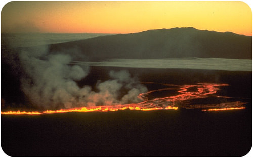
The most obvious landforms created by lava are volcanoes, most commonly as cinder cones, composite volcanoes, and shield volcanoes. Eruptions also take place through other types of vents, commonly from fissures (Figurebelow). The eruptions that created the entire ocean floor are essentially fissure eruptions.
A fissure eruption on Mauna Loa in Hawaii travels toward Mauna Kea on the Big Island.
Lava Domes
Viscous lava flows slowly. If there is not enough magma or enough pressure to create an explosive eruption, the magma may form a lava dome. Because it is so thick, the lava does not flow far from the vent. (Figurebelow).
Lava domes are large, round landforms created by thick lava that does not travel far from the vent.
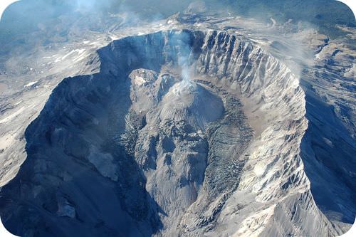
Lava flows often make mounds right in the middle of craters at the top of volcanoes, as seen in the Figurebelow.
Lava domes may form in the crater of composite volcanoes as at Mount St. Helens.
Lava Plateaus
A lava plateau forms when large amounts of fluid lava flow over an extensive area (Figurebelow). When the lava solidifies, it creates a large, flat surface of igneous rock.
Layer upon layer of basalt have created the Columbia Plateau, which covers more than 161,000 square kilometers (63,000 square miles) in Washington, Oregon, and Idaho.
Land
Lava creates new land as it solidifies on the coast or emerges from beneath the water (Figurebelow).
Lava flowing into the sea creates new land in Hawaii.
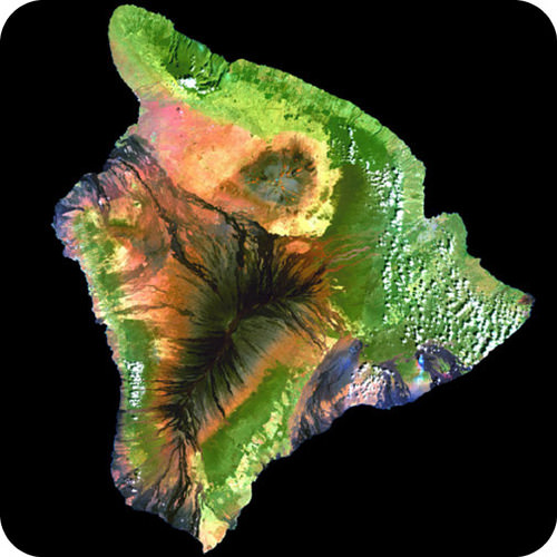
Over time the eruptions can create whole islands. The Hawaiian Islands are formed from shield volcano eruptions that have grown over the last 5 million years (Figurebelow).
The island of Hawaii was created by hotspot volcanism. You can see some of the volcanoes (both active and extinct) in this mosaic of false-color composite satellite images.
Landforms from Magma
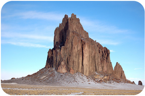
Magma intrusions can create landforms. Shiprock in New Mexico is the neck of an old volcano that has eroded away (Figurebelow). The volcanic neck is the remnant of the conduit the magma traveled up to feed an eruption.
The aptly named Shiprock in New Mexico.
Summary
Landforms created by lava include volcanoes, domes, and plateaus.
New land can be created by volcanic eruptions.
Landforms created by magma include volcanic necks and domes.
Review
What is Shiprock and how did it form?
How do lava plateaus form?
What types of landforms are created by very viscous magma?
Explore More
Use this resource to answer the questions that follow.
How many separate eruptions created the basalts at Quincy, Washington?
How thick is the basalt?
When did the lavas begin to erupt?
How do scientists know that the Cascade volcanoes didn't erupt these lavas?
What type of volcanic vent did the eruptions come from?
What is the origin of all this volcanism?
How are the flows in eastern Washington different from those in Hawaii today?
NOTES / HIGHLIGHTS
Please Sign In to create your own Highlights / Notes
Vocabulary
termdefinition
lava domea dome-shaped plug of viscous lava that cools near the vent of a volcano.
lava plateaua flat, wide surface formed when lava comes out of the ground and spreads out very quickly.
Notes/Highlights
Color
Highlighted Text
Notes
Please Sign In to create your own Highlights / Notes


 FlexiA FREE Digital Tutor for Every Student
 FlexBooks 2.0Customizable, digital textbooks in a new, interactive platform
 FlexBooksCustomizable, digital textbooks
 SchoolsFlexBooks from schools and districts near you
 Study GuidesQuick review with key information for each concept
 Adaptive PracticeBuilding knowledge at each student’s skill level
 SimulationsInteractive Physics & Chemistry Simulations
 PLIXPlay. Learn. Interact. eXplore.
 CCSS MathConcepts and FlexBooks aligned to Common Core
 NGSSConcepts aligned to Next Generation Science Standards
 Certified EducatorStand out as an educator. Become CK-12 Certified.
 WebinarsLive and archived sessions to learn about CK-12