9.14Landforms from Erosion and Deposition by Gravity
Difficulty Level: At Grade | Created by: CK-12
Last Modified: Aug 02, 2016
Loading...
Would you live here?
La Conchita, California is in a beautiful location, nestled between a Southern California beach and a hillside. That hillside, though, is prone to landslides, and the town has lost several homes, a banana plantation, and 10 residents to landslides in 1995 and 2005. Despite these problems people stay in the community. Would you?
Landforms and Gravity
Gravity shapes the Earth’s surface by moving weathered material from a higher place to a lower one. This occurs in a variety of ways and at a variety of rates, including sudden, dramatic events as well as slow, steady movements that happen over long periods of time. The force of gravity is constant and it is changing the Earth’s surface right now.
Downslope Movement by Gravity
Erosion by gravity is called mass wasting. Mass wasting can be slow and virtually imperceptible, or rapid, massive, and deadly.
Weathered material may fall away from a cliff because there is nothing to keep it in place. Rocks that fall to the base of a cliff make a talus slope. Sometimes as one rock falls, it hits another rock, which hits another rock, and begins a landslide.
Landslides
Landslides are the most dramatic, sudden, and dangerous examples of Earth materials moved by gravity. Landslides are sudden falls of rock; by contrast, avalanches are sudden falls of snow.
When large amounts of rock suddenly break loose from a cliff or mountainside, they move quickly and with tremendous force (Figurebelow). Air trapped under the falling rocks acts as a cushion that keeps the rock from slowing down. Landslides can move as fast as 200 to 300 km/hour.
This landslide in California in 2008 blocked Highway 140.
Landslides are exceptionally destructive. Homes may be destroyed as hillsides collapse. Landslides can even bury entire villages. Landslides may create lakes when the rocky material dams a stream. If a landslide flows into a lake or bay, they can trigger a tsunami.
Landslides often occur on steep slopes in dry or semi-arid climates. The California coastline, with its steep cliffs and years of drought punctuated by seasons of abundant rainfall, is prone to landslides.
Mudflows and Lahars
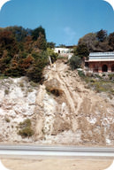
Added water creates natural hazards produced by gravity (Figurebelow). On hillsides with soils rich in clay, little rain, and not much vegetation to hold the soil in place, a time of high precipitation will create a mudflow. Mudflows follow river channels, washing out bridges, trees, and homes that are in their path.
Mudflows are common in southern California.
A lahar is mudflow that flows down a composite volcano (Figurebelow). Ash mixes with snow and ice melted by the eruption to produce hot, fast-moving flows. The lahar caused by the eruption of Nevado del Ruiz in Columbia in 1985 killed more than 23,000 people.
A lahar is a mudflow that forms from volcanic ash and debris.
Slump and Creep
Less dramatic types of downslope movement move Earth materials slowly down a hillside. Slump moves materials as a large block along a curved surface (Figurebelow). Slumps often happen when a slope is undercut, with no support for the overlying materials, or when too much weight is added to an unstable slope.
Slump material moves as a whole unit, leaving behind a crescent shaped scar.
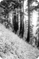
Creep is the extremely gradual movement of soil downhill. Curves in tree trunks indicate creep because the base of the tree is moving downslope while the top is trying to grow straight up (Figurebelow). Tilted telephone or power company poles are also signs of creep.
The trunks of these trees near Mineral King, California, were bent by snow creeping downhill when the trees were saplings.
Contributing Factors
There are several factors that increase the chance that a landslide will occur. Some of these we can prevent and some we cannot.
Water
A little bit of water helps to hold grains of sand or soil together. For example, you can build a larger sand castle with slightly wet sand than with dry sand. However, too much water causes the sand to flow quickly away. Rapid snow melt or rainfall adds extra water to the soil, which increases the weight of the slope and makes sediment grains lose contact with each other, allowing flow.
Rock Type
Layers of weak rock, such as clay, also allow more landslides. Wet clay is very slippery, which provides an easy surface for materials to slide over.
Undercutting
If people dig into the base of a slope to create a road or a homesite, the slope may become unstable and move downhill. This is particularly dangerous when the underlying rock layers slope towards the area.
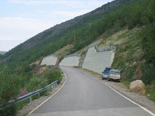
When construction workers cut into slopes for homes or roads, they must stabilize the slope to help prevent a landslide (Figurebelow). Tree roots or even grasses can bind soil together. It is also a good idea to provide drainage so that the slope does not become saturated with water.
A rock wall stabilizes a slope that has been cut away to make a road.
Ground Shaking
An earthquake, volcanic eruption, or even just a truck going by can shake unstable ground loose and cause a slide. Skiers and hikers may disturb the snow they travel over and set off an avalanche.
Prevention and Awareness
Landslides cause $1 billion to $2 billion damage in the United States each year and are responsible for traumatic and sudden loss of life and homes in many areas of the world.
Some at-risk communities have developed landslide warning systems. Around San Francisco Bay, the National Weather Service and the U.S. Geological Survey use rain gauges to monitor soil moisture. If soil becomes saturated, the weather service issues a warning. Earthquakes, which may occur on California’s abundant faults, can also trigger landslides.
To be safe from landslides:
Be aware of your surroundings and notice changes in the natural world.
Look for cracks or bulges in hillsides, tilting of decks or patios, or leaning poles or fences when rainfall is heavy. Sticking windows and doors can indicate ground movement as soil pushes slowly against a house and knocks windows and doors out of alignment.
Look for landslide scars because landslides are most likely to happen where they have occurred before.
Plant vegetation and trees on the hillside around your home to help hold soil in place.
Help to keep a slope stable by building retaining walls. Installing good drainage in a hillside may keep the soil from getting saturated.
Hillside properties in the San Francisco Bay Area and elsewhere may be prone to damage from landslides. Geologists are studying the warning signs and progress of local landslides to help reduce risks and give people adequate warnings of these looming threats.
Summary
Landslides are sudden and massive falls of rock down a slope that may be very destructive or even deadly. Mudflows or lahars, which are volcanic mudflows, are mass movements that contain a lot of water. Slump and creep are slower types of mass wasting.
Mass movements are more likely to occur on slopes that are wet, have weak rock, or are undercut. An earthquake or other ground shaking can trigger a landslide.
To avoid being in a landslide, be aware of signs in a hillside, such as cracks or bulges and old landslide scars.
To keep a slope stable, install good drainage or build retaining walls.
Review
How would installing drainage pipes in a slope change that slope's chance of a landslide?
If you look at a hillside, how can you tell that it's vulnerable to landslides? How can you tell that it's vulnerable to creep?
What is the scenario that creates a mudflow that kills 23,000 people?
Explore More
Use these resources to answer the questions that follow.
What is usually involved in starting a landslide?
What must be sitting on the slope waiting? What creates this material?
What starts the landslide?
In dry Arizona, how could a landslide happen?
What else can trigger landslides?
Vocabulary
termdefinition
creepexceptionally slow movement of soil downhill.
landsliderapid movement downslope of rock and debris under the influence of gravity.
mudflowsaturated soil that flows down river channels.
slumpdownslope slipping of a mass of soil or rock, generally along a curved surface.
talus slopea pile of angular rock fragments formed at the base of a cliff or mountain.
Notes/Highlights
Color
Highlighted Text
Notes
Please Sign In to create your own Highlights / Notes
 FlexiA FREE Digital Tutor for Every Student
 FlexBooks 2.0Customizable, digital textbooks in a new, interactive platform
 FlexBooksCustomizable, digital textbooks
 SchoolsFlexBooks from schools and districts near you
 Study GuidesQuick review with key information for each concept
 Adaptive PracticeBuilding knowledge at each student’s skill level
 SimulationsInteractive Physics & Chemistry Simulations
 PLIXPlay. Learn. Interact. eXplore.
 CCSS MathConcepts and FlexBooks aligned to Common Core
 NGSSConcepts aligned to Next Generation Science Standards
 Certified EducatorStand out as an educator. Become CK-12 Certified.
 WebinarsLive and archived sessions to learn about CK-12