The epicenter of the 2011 Japan earthquake was just offshore of Sendai where the Pacific Plate plunges into a subduction zone. The quake had a relatively shallow depth of 20 miles (32 km). Remember that shallow quakes typically cause the most damage. How do scientists find an earthquake epicenter?
Finding the Epicenter
Here are the steps to finding an earthquake epicenter using three seismograms:
1. Determine the epicenter distance from three different seismographs. The longer the time between the arrival of the P-wave and S-wave, the farther away is the epicenter. So the difference in the P- and S-wave arrival times determines the distance between the epicenter and a seismometer.
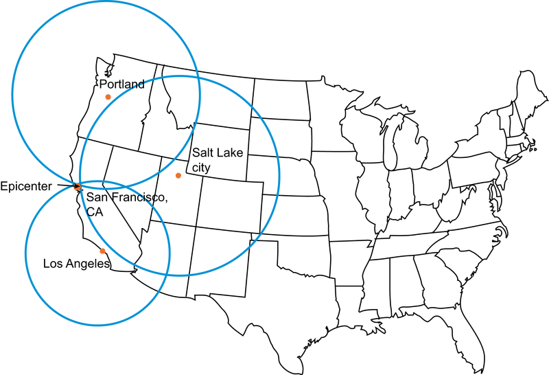
2. Draw a circle with a radius equal to the distance from the epicenter for that seismograph. The epicenter is somewhere along that circle. Do this for three locations. Using data from two seismographs, the two circles will intercept at two points. A third circle will intercept the other two circles at a single point. This point is the earthquake epicenter (Figurebelow).
Three circles drawn from three seismic stations each equal to the radius from the station to the epicenter of the quake will intercept at the actual epicenter.
Of course, it's been a long time since scientists drew circles to locate an earthquake epicenter. This is all done digitally now. but it's a great way to learn the basics of how locating an epicenter works.
Summary
To find an earthquake epicenter you need at least three seismographs.
Find the distance from each seismograph to the earthquake epicenter.
The interception of the three circles is the epicenter.
Review
How do you determine the distance from the seismograph to the earthquake epicenter?
How do you find the epicenter from three seismographs? What if you have more seismographs involved?
In what circumstance would three seismographs not give you enough information to find an earthquake epicenter?
Explore More
Use this resource to answer the questions that follow.
What is the difference in P- and S-wave arrival times at Salt Lake City?
How do you find out how far away the epicenter of the quake was from SLC?
What is the distance to the epicenter from Salt Lake City? So where is the epicenter?
When you know the distance from SLC and from Houston, where is the epicenter?
When you have three circles around three cities, how do you know where the epicenter is?
Notes/Highlights
Color
Highlighted Text
Notes
Please Sign In to create your own Highlights / Notes


 FlexiA FREE Digital Tutor for Every Student
 FlexBooks 2.0Customizable, digital textbooks in a new, interactive platform
 FlexBooksCustomizable, digital textbooks
 SchoolsFlexBooks from schools and districts near you
 Study GuidesQuick review with key information for each concept
 Adaptive PracticeBuilding knowledge at each student’s skill level
 SimulationsInteractive Physics & Chemistry Simulations
 PLIXPlay. Learn. Interact. eXplore.
 CCSS MathConcepts and FlexBooks aligned to Common Core
 NGSSConcepts aligned to Next Generation Science Standards
 Certified EducatorStand out as an educator. Become CK-12 Certified.
 WebinarsLive and archived sessions to learn about CK-12