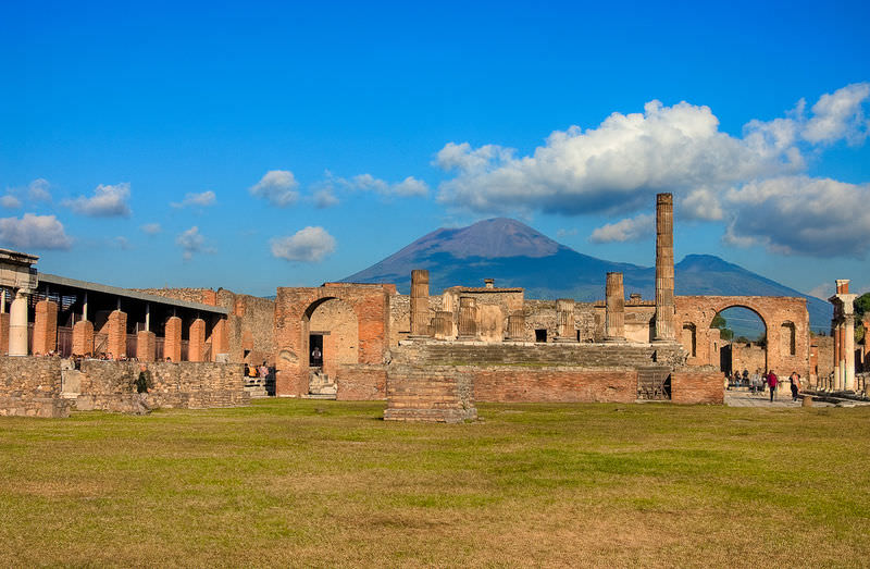
Nearly 2,000 years later, the explosive eruption of Mt. Vesuvius remains one of the most talked about eruptions in history. It began with a column of ash that blanketed the area, which was followed by fast-moving, dense, and scorching-hot pyroclastic flows. People suffocated or burnt, and structures in two thriving Roman cities were destroyed. Remains of some of the dead can be seen at Pompeii, where people were entombed in scorching ash. The eruption type was named plinian, after Pliny the Younger, who watched from offshore.
Explosive Eruptions
A large explosive eruption creates even more devastation than the force of the atom bomb dropped on Nagasaki at the end of World War II, in which more than 40,000 people died. A large explosive volcanic eruption is 10,000 times as powerful. Explosive eruptions are found at the convergent plate boundaries that line parts of western North America, resulting in the Cascades in the Pacific Northwest and the Aleutians in Alaska.
Causes of the Explosion
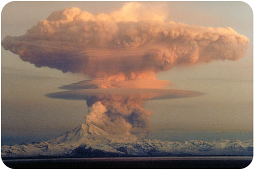
Explosive eruptions are caused by gas-rich, felsic magmas that churn within the magma chamber. When the pressure becomes too great the magma breaks through the rock above the chamber and explodes, just like when a cork is released from a bottle of champagne. Magma, rock, and ash burst upward in an enormous explosion (Figurebelow).
Ash and gases create a mushroom cloud above Mt. Redoubt in Alaska, 1989. The cloud reached 45,000 feet and caught a Boeing 747 in its plume.
Pyroclastic Material
The erupted rock fragments are called tephra. Ash and gas also explode from the volcano. Scorching hot tephra, ash, and gas may speed down the volcano’s slopes at 700 km/h (450 mph) as a pyroclastic flow. Pyroclastic means fire rock (Figurebelow).
Left: An explosive eruption from the Mayon Volcano in the Philippines in 1984. Ash flies upward into the sky and pyroclastic flows pour down the mountainside. Right: The end of a pyroclastic flow at Mount St. Helens.
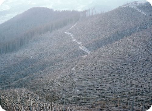
Pyroclastic flows knock down everything in their path. The temperature inside a pyroclastic flow may be as high as 1,000°C (1,800°F).
Blowdown of trees near Mount St. Helens shows the direction of the blast and pyroclastic flow.
Cascades Volcanoes
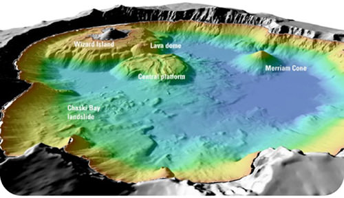
Prior to the Mount St. Helens eruption in 1980, the Lassen Peak eruption on May 22, 1915, was the most recent Cascades eruption. A column of ash and gas shot 30,000 feet into the air. This triggered a high-speed pyroclastic flow, which melted snow and created a volcanic mudflow known as a lahar. Lassen Peak currently has geothermal activity and could erupt explosively again. Mt. Shasta, the other active volcano in California, erupts every 600 to 800 years. An eruption would most likely create a large pyroclastic flow, and probably a lahar. Of course, Mt. Shasta could explode and collapse like Mt. Mazama in Oregon (Figurebelow).
Crater Lake fills the caldera of the collapsed Mt. Mazama, which erupted with 42 times more power than Mount St. Helens in 1980. The bathymetry of the lake shows volcanic features such as cinder cones.
Volcanic Gases
Volcanic gases can form poisonous and invisible clouds in the atmosphere. These gases may contribute to environmental problems such as acid rain and ozone destruction. Particles of dust and ash may stay in the atmosphere for years, disrupting weather patterns and blocking sunlight (Figurebelow).
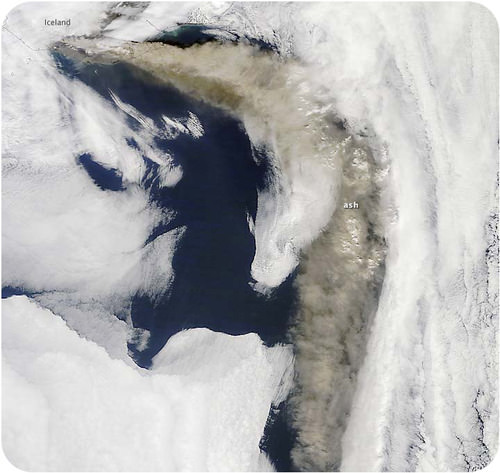
The ash plume from Eyjafjallajökull volcano in Iceland disrupted air travel across Europe for six days in April 2010.
Pyroclastic eruption types include tephra, ash, and lahars.
Mt. Mazama blew its top off and then collapsed, creating Crater Lake in Oregon.
Review
Why do convergent plate boundaries have explosive eruptions?
Why do felsic magmas erupt explosively?
How do volcanic gases affect the atmosphere?
Vocabulary
termdefinition
explosive eruptionvolcanic eruption that releases large amounts of gas, so that rock, lava, and ash is violently thrown up into the air.
lahara volcanic mudflow containing pyroclastic material (ash and rock) and water from melting snow or rainfall that races down river valleys during an eruption.
pyroclastic flowhot ash, gas, and rock that race down a volcano’s slopes during an explosive eruption.
tephrafragments of material produced in a volcanic eruption.
Notes/Highlights
Color
Highlighted Text
Notes
Please Sign In to create your own Highlights / Notes


 FlexiA FREE Digital Tutor for Every Student
 FlexBooks 2.0Customizable, digital textbooks in a new, interactive platform
 FlexBooksCustomizable, digital textbooks
 SchoolsFlexBooks from schools and districts near you
 Study GuidesQuick review with key information for each concept
 Adaptive PracticeBuilding knowledge at each student’s skill level
 SimulationsInteractive Physics & Chemistry Simulations
 PLIXPlay. Learn. Interact. eXplore.
 CCSS MathConcepts and FlexBooks aligned to Common Core
 NGSSConcepts aligned to Next Generation Science Standards
 Certified EducatorStand out as an educator. Become CK-12 Certified.
 WebinarsLive and archived sessions to learn about CK-12