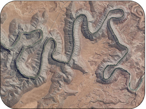
In Southeastern Utah, stream meanders have been immortalized by erosion into the Goosenecks of the San Juan River. This satellite image shows the amazing path the river has cut. Even better is to stand at the edge and look into one of the meanders. Goosenecks State Park is in the southeastern corner of Utah.
Erosion by Streams
Flowing streams pick up and transport weathered materials by eroding sediments from their banks. Streams also carry ions and ionic compounds that dissolve easily in the water.
Sediment Transport
Sediments are carried as:
Dissolved load: Dissolved load is composed of ions in solution. These ions are usually carried in the water all the way to the ocean.
Suspended load: Sediments carried as solids as the stream flows are suspended load. The size of particles that can be carried is determined by the stream’s velocity (Figurebelow). Faster streams can carry larger particles. Slower streams can only carry smaller particles. Streams with a steep gradient (slope) have a faster velocity and can carry larger particles.
The Amazon River appears brown when carrying a large sediment load.
Bed load: Some particles are too large to be carried as suspended load. These particles bumped and pushed along the stream bed as bed load. Bed load sediments do not move continuously. This intermittent movement is called saltation. Streams with high velocities and steep gradients cut down into the stream bed. This type of erosion is primarily by movement of particles that make up the bed load.
Stream Deposition
A stream is at its base level where it meets a large body of water. As a stream gets closer to base level, its gradient lowers. The stream deposits more material than it erodes. On flatter ground, streams deposit material on the inside of meanders. Meanders are bends in the stream's path. Placer mineral deposits are often deposited on the inside of meanders.
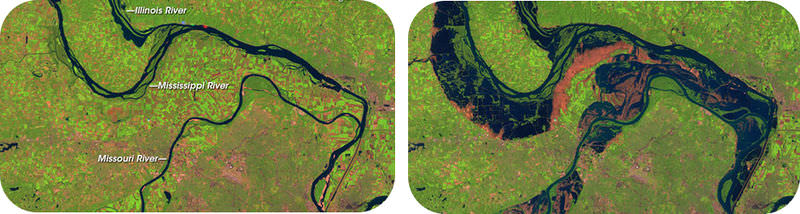
A stream’s floodplain is much broader and shallower than its channel. When a stream flows onto its floodplain, its velocity slows. The stream deposits much of its load. Stream sediments are rich in nutrients and make excellent farmland. The Mississippi River floodplain is heavily farmed. Flooding can wipe out farms and towns, but the stream also deposits nutrient-rich sediments that enrich the floodplain (Figurebelow).
The Mississippi River floodplain at normal flow and during flood.
A stream at flood stage carries lots of sediments. When its gradient decreases, the stream overflows its banks and broadens its channel. The decrease in gradient causes the stream to deposit its sediments. The largest sediments are deposited first. These large sediments build a higher area around the edges of the stream channel. This creates a natural levee.
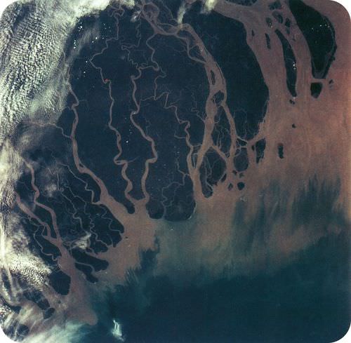
When a river enters standing water, its velocity slows to a stop. The stream moves back and forth across the region. The stream drops its sediments in a wide triangular-shaped deposit called a delta (Figurebelow).
The Ganges River forms an enormous delta in Bangladesh.
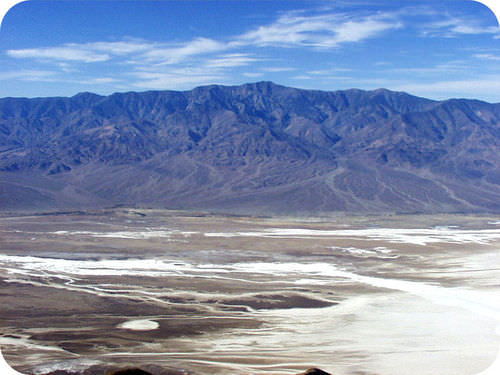
If a stream falls down a steep slope onto a broad flat valley, an alluvial fan develops (Figurebelow). Alluvial fans generally form in arid regions.
A series of alluvial fans spread out from mountains along the Badwater Basin in Death Valley, California.
ScienceFriday: The Lollipop Hypothesis
Ever wondered how many licks it takes to reach the center of a lollipop? Mathematicians at NYU’s applied mathematics lab have designed experiments to determine this. Find out in this video by ScienceFriday.
Summary
Streams carry dissolved ions and sediments. The sizes of the sediments a stream can carry depend on the stream's velocity.
Particles that are too large to be suspended move along the stream bed by saltation.
Rivers deposit sediments on levees, floodplains, and in deltas and alluvial fans.
Review
If flood waters decrease, what will happen to the size of particle the stream can carry? What will be deposited and where?
Under what conditions do streams cut down into their beds? Under what conditions do they erode their banks?
Deserts are extremely dry, yet alluvial fans are said to be deposited by stream flow. Describe how this occurs.
Explore More
Use the resource below to answer the questions that follow.
1. What are the factors that change a straight stretch of river into a curvy section?
2. How are the banks of a river weakened?
3. What effect does dirt collecting on the riverbanks have on a river?
4. How is a new curve carved?
5. How is an ox-bow lake formed?
Vocabulary
termdefinition
alluvial fancurved, fan-shaped, coarse-sediment deposit that forms when a stream meets flat ground.
base levelwhere a stream meets a large body of standing water, usually the ocean.
bed loadsediments moved by rolling or bumping along the stream bed.
competencea measure of the largest particle a stream can carry.
deltaa triangular-shaped deposit of sediments that forms where a river meets standing water.
dissolved loadthe elements carried in solution by a stream.
gradientthe slope of a stream.
meandera bend or curve in a stream channel.
saltationfine particles are lifted into the air (or water of a river) for a short distance and then fall; the particles hop along the surface.
suspended loadsolid particles that are carried in the main stream flow.
Notes/Highlights
Color
Highlighted Text
Notes
Please Sign In to create your own Highlights / Notes


 FlexiA FREE Digital Tutor for Every Student
 FlexBooks 2.0Customizable, digital textbooks in a new, interactive platform
 FlexBooksCustomizable, digital textbooks
 SchoolsFlexBooks from schools and districts near you
 Study GuidesQuick review with key information for each concept
 Adaptive PracticeBuilding knowledge at each student’s skill level
 SimulationsInteractive Physics & Chemistry Simulations
 PLIXPlay. Learn. Interact. eXplore.
 CCSS MathConcepts and FlexBooks aligned to Common Core
 NGSSConcepts aligned to Next Generation Science Standards
 Certified EducatorStand out as an educator. Become CK-12 Certified.
 WebinarsLive and archived sessions to learn about CK-12